Laindon Road - 250 Houses - Planning Application xx/xxxxx/xxxx
The planning application can be found on Basildon council's ePlanning system through this link
wwwwwwwww.
The deadline to comment or object is xx xxxxx xxxx.
wwwwwwwww.
The deadline to comment or object is xx xxxxx xxxx.
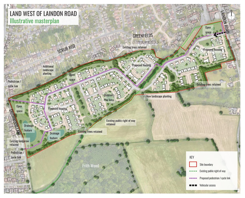
Proposed site layout
Outline details
A development of 250 houses on land running between Laindon Road and Frithwood Lane.
Access from Laindon Road near to The Fold.
The existing footpath (no. 23) will be retained but will in part run alongside the estate road and housing. The path will also be crossed by the estate road at one point.
A new footpath and cycle way will run from Laindon Road to Frithwood Lane through the estate.
It is proposed that many of the existing trees (some have tree preservation orders) and hedge lines will be retained and that there will be some new landscape planting.
At the closest point the development will approximately 220m from ancient Frith Wood.
Drainage ponds will be created at the lower end of the site near to Frithwood Lane as part of a public open space.
Observations and concerns
- This is Green Belt land as defined under Basildon council's saved policies.
Green Belt Review 2017
This site is part of Parcel 12 in Basildon council's Green Belt Review 2017. That review will inform any decision to allow, or not, development on the land.
There are 5 primary purposes of the Green Belt. All sites contribute to purpose 5 so that is not detailed in the review extract below. . However, this site contributed to 2 or the other 4 purposes as shown.
We contest that it also fully contributes to purpose 2 if the potential coalescence with Little Burstead is correctly taken into consideration, rather than overlooking that historic community as the Green Belt review shows.
In our view, this parcel of land strongly contributes to all 5 purposes of the Green Belt.
Landscape Appraisal 2017
Another key document is Basildon council's Landscape Appraisal 2017. This site is known as Site 7.
This too will inform the appropriateness of allowing development on the site.
This too will inform the appropriateness of allowing development on the site.
Withdrawn Local Plan
This site was part of allocation H17d in the now withdrawn Local Plan which at the time proposed 520 house and the relief/link road running through the site.
The current planning application proposes to use just the northern edge of that site for 250 houses. There will be no relief or link road.
The following are extracts from the withdrawn Local Plan. The outlined paragraphs are our emphasis.
The current planning application proposes to use just the northern edge of that site for 250 houses. There will be no relief or link road.
The following are extracts from the withdrawn Local Plan. The outlined paragraphs are our emphasis.


